Search
Niger State

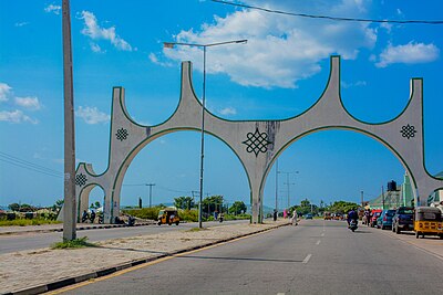
Niger is a state in the North Central region of Nigeria and the largest state in the country by area. Niger state has three political zones, zone A, B and C. The state's capital is at Minna. Other major cities are Bida, Kontagora and Suleja. It was formed in 1976 when the then North-Western State was divided into Niger State and Sokoto State. It is home to Ibrahim Babangida and Abdulsalami Abubakar, two of Nigeria's former military rulers. The Nupe,Adara, Gbagyi, Kamuku, Kambari, Gungawa, Hun-Saare, Hausa and Koro form the majority of numerous indigenous tribes of Niger State.
The state is named after the River Niger. Two of Nigeria's major hydroelectric power stations, the Kainji Dam and Shiroro Dam, are located in Niger State, along with the new Zungeru Dam. The Jebba Dam straddles the border of Niger state and Kwara state. The famous Gurara Falls is in Niger State, and Gurara Local Government Area is named after the Gurara River, on whose course the fall is situated. Also situated there is Kainji National Park, the largest National Park of Nigeria, which contains Kainji Lake, the Borgu Game Reserve and the Zugurma Game Reserve.
Government
Like most Nigerian states, Niger State is governed by a democratically-elected Governor, who is currently Mohammad Umar Bago. The governor works with the Niger State House of Assembly. The capital city is Minna.
The state has three Senatorial Zones/Districts: Niger East, Niger North, Niger South.
Electoral system
The governor is selected using a modified two-round system. To be elected in the first round, a candidate must receive the plurality of the vote and over 25% of the vote in at least two -third of the State local government Areas. If no candidate passes threshold, a second round will be held between the top candidate and the next candidate to have received a plurality of votes in the highest number of local government Areas.
Local government
The state has of 25 Local Government Areas, each headed by a local government chairman. The areas which are divided into districts, each with a district head while. Villages are headed by village heads throughout the state.
The local government areas are:
Education
Tertiary educational institutions in Niger state include:
- Federal College of Education, Kontagora
- Federal Polytechnic, Bida
- Federal University of Technology Minna
- Ibrahim Badamasi Babangida University, Lapai
- Niger State College of Education Minna
- Niger State Polytechnic, Zungeru
Transport
Federal Highways are:
- A1 north from Ilorin in Kwara State across the Niger River by a four-lane bridge at Jebba for 388 km as part of the African Unity Road (TAH2: Trans-African Highway 2) to Kontagora, then via Ibeto to Yelwa in Kebbi State.
- A125 continuing TAH2 east from A1 at Kontagora via Tegina to Kaduna State at Gishiri.
- A124 east from A1 north of Mokwa via Bida and Agaie as the Bida-Abuja Rd to Abuja, FCT at Kudan.
Two roads to Benin:
- The Wana-Babana Rd at Babana to Basso.
- Agwara Tungar Jatau Swate Maje Rd from Agwarra via Konkwesso to RNIE 7 to Ségbana.
Other Major Roads include:
- The Minna-Tagbari Rd northeast to Kaduna State as the Chibian-Zazaga-Sarkin Pawa Rd
- The Minna-Bida Rd
- The Mararaba-Makutu-Mapi Rd southeast from Minna via Matumbi and Paiko to A124 at Daga
- Yelwa-Mokwa Rd across the Niger River by a bridge from Kato to Jinjima
Railways:
the Western Line north from Lagos via Ibadan and Ilorin across the Niger River at Jebba by a 547 m bridge (1915) via Minna to Kaduna, with a branch line from Minna 155 km to the port of Baro on the Niger River, which is connected with Kano by the Northern Line.
Airports:
- Minna Airport
Natural resources
Niger State has abundant natural resources, including:
Languages
Languages of Niger State listed by LGA:
Geography
Climate
The state has very warm climate with a yearly average of 34° Celsius. It is warm or hot all year, but there are few typically tropical and sultry months, although humidity is sometimes uncomfortably high in June to September. The best time for traveling is from November to April, when there is less rain. The rainiest days occur in May to October. September has the rainiest days, and December the least. January is the sunniest month, and August the least sunny.
Gallery
See also
- List of governors of Niger State
- List of villages in Niger State
- Niger State Local Government Areas
References
External links
Media related to Niger State at Wikimedia Commons
- Official portal
- News on Niger State
Text submitted to CC-BY-SA license. Source: Niger State by Wikipedia (Historical)
Owlapps.net - since 2012 - Les chouettes applications du hibou


